

Brief History and Geology of Fosdalen
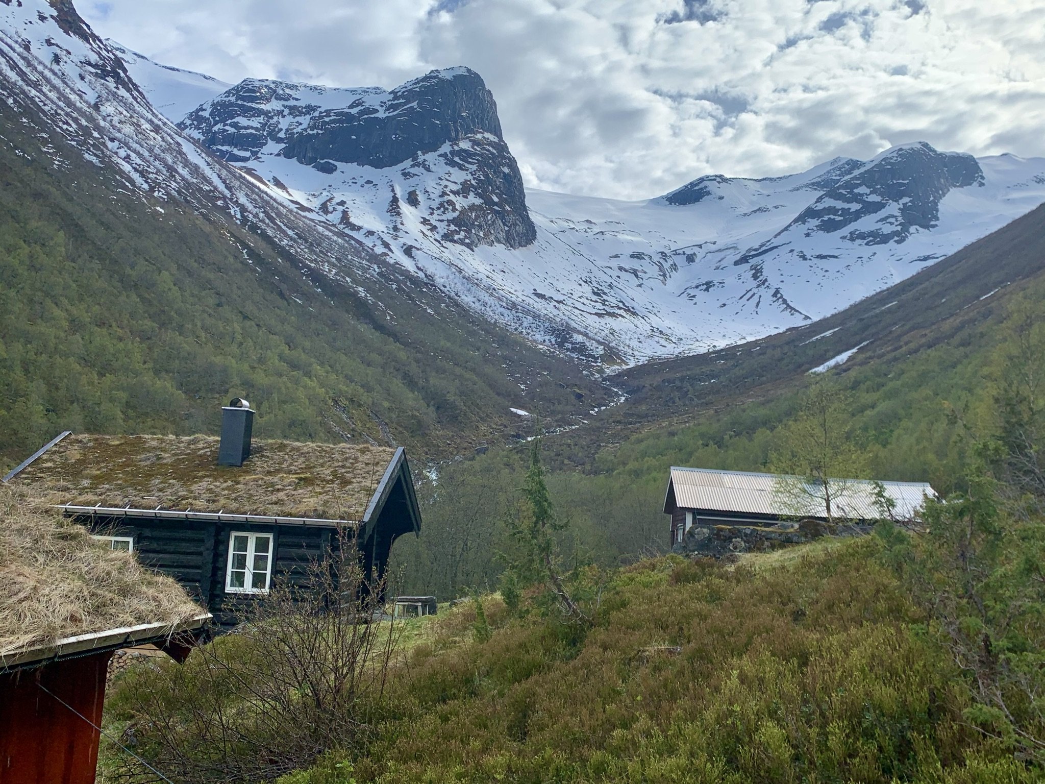
Fosdalssetra with Tafsehyrna and Fosdalsbreen in the background.
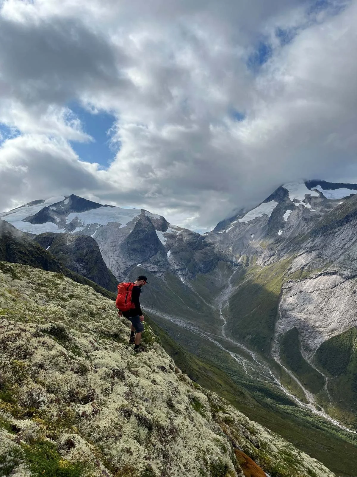
The Historic Route to Loen
The old route from Oppstryn to Loen passes through Fosdalen, over a mountain pass known as Tyvareset (approximately 1,260 metres above sea level), and then descends through the valley leading to Loen. People from Loen refer to the valley on their side as Fosdalen, while people from Oppstryn call it Tyvadalen.
The route across Tyvareset has seen little use in recent years. However, before roads were built along Oppstrynsvatnet and the fjord between Tonning and Loen, it served as an travel route between the two communities.
Old church records tell of a man who is believed to have perished while crossing the pass. The record states:
“Around the middle of June 1832, the farmer David Andersen Skarsteen, about 30 years of age, disappeared in the glacier situated between Oppstryn and Loen. As soon as his absence was noticed, a search was carried out, but no trace of him was found. It is presumed that bad weather or unfamiliarity with the route caused his death.”
The term “Little Ice Age” is used to describe a colder climatic period during which glaciers expanded significantly. This period is generally considered to have lasted from around 1500 to 1850, with the glaciers reaching their greatest extent around 1750. During this time, and well into more recent history, a glacier covered Tyvareset.
In 1893, Akslun Jenssen Løken leased a smallholding belonging to Farm No. 4 at Berge. It is said that he bought a heifer at Sæten in Loen and drove it through Tyvadalen, across Tyvareset, down through Fosdalen and onwards to Berge. According to local tradition, the journey went well. People in those days were not afraid of hard work and long journeys. (Source: Amund Mork)
In 1935 (or possibly 1936), Jørgen Grønfur, a glacier guide, was commissioned by the Norwegian Trekking Association (DNT) to mark the trail across Tyvareset. Ragnar Grønfur assisted with the work. Although the route was marked, it did not lead to any significant increase in the number of hikers using the trail.

Tyvareset. View towards Hjelledalen Photo: Tarald Harstad

Tyvareset. View towards Tyvadalen Photo: Tarald Harstad
Hunting and Trapping Structures below Tafsehyrna
In 2017, the municipality of Stryn was working on a local heritage plan. During this process, Amund Mork contacted the municipality to report a stone wall he had discovered below Tafsehyrna. He believed it had cultural and historical significance, but his observations were not taken seriously at first.
Rannveig Marit Mindresunde became interested in the matter and contacted the expert Runar Hole to help determine what the wall might represent.

The Barrier Wall below Tafsehyrna. A lookout post can be seen at the far end. Photo: Fjordingen

The Hunting and Trapping Site below Tafsehyrna Photo: Fjordingen
Runar Hole, an expert on ancient hunting structures, has confirmed that the stone wall (marked with a red line in the photograph) formed part of a hunting and trapping system from ancient times. It is difficult to determine exactly when the site was in use, but it may date back as far as the Stone Age, more than 4,000 years ago.
The illustration above shows how wild reindeer are believed to have been driven towards a position where hunters stood ready with spears, bows and arrows.
The barrier wall shown in the second photograph guided the reindeer up a ridge running just below the mountain. Here, the animals were forced into a narrow passage where hunters could reach them with bows and arrows. To inflict a fatal wound, the hunter needed to be within about 20 metres of the animal. Spears required an even shorter distance.
At the lower end of the wall there was a lookout post. Hunters probably lay concealed along the wall to prevent the herd from crossing it, while other hunters waited behind a large boulder beneath the steep mountainside (marked with a red circle in the photograph). This was a well-organised hunt involving many participants.
Rannveig also contacted place-name researchers to investigate whether there might be a connection between the hunting site and the name of the mountain above it. Their conclusion was that such a connection is highly likely.
Tafn is an Old Norse word meaning prey or offering. It is likely that the word gradually evolved into Tafs in the name Tafsehyrna. The traditional explanation—that the scree at the summit resembles tassels or fringes—is no longer considered the most probable origin of the name.
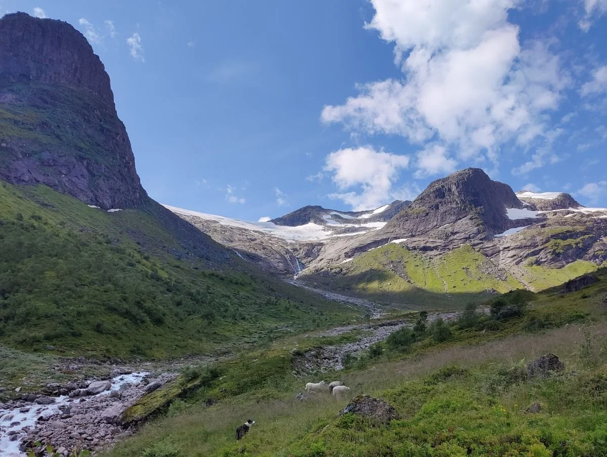
The Blueberry Harvest
Fosdalen is rich in wild blueberries. In earlier times, picking blueberries was a common way of earning extra income.
Ingeborg Sandvik was especially skilled at gathering blueberries and was known for her strength. Ingebrikt Sandvik recalled that she often returned from Fosdalen carrying a kipe (a traditional wicker basket) on her back filled with blueberries. The berries weighed about 50 kilograms, while the basket itself weighed 7.5 kilograms. Ingebrikt had personally helped weigh the load. Ingeborg lived to the remarkable age of 103.
Blueberries are a resource that receives little attention today. Few foods are richer in antioxidants than blueberries, and research suggests that antioxidants are most beneficial when obtained from natural foods. Studies have indicated that blueberries may help reduce the risk of certain cancers and lower cholesterol levels.

There are plenty of blueberries in Fosdalen
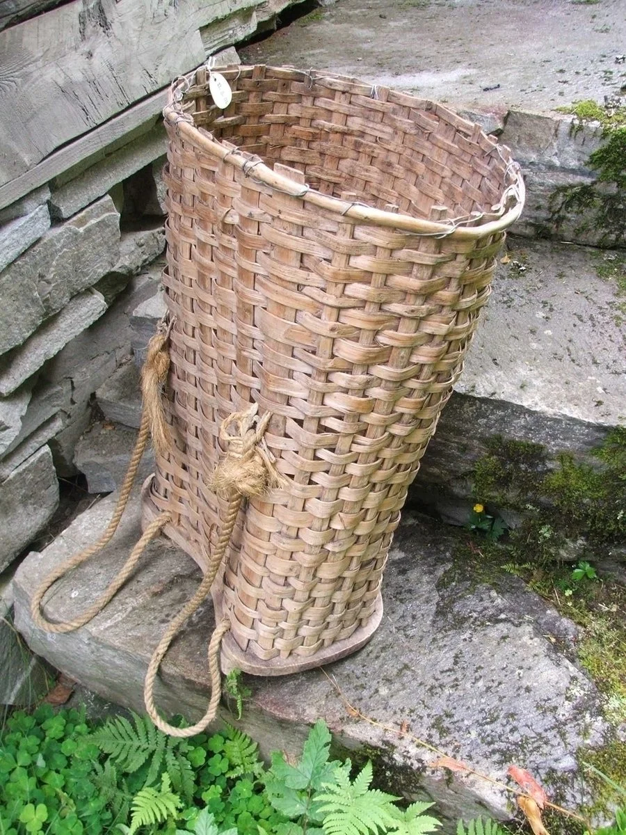
Kipe
A kipe was a large basket used for carrying goods, traditionally made from wood or woven willow branches. It was commonly used in Norway in the past, especially by farmers and fishermen, to transport hay, firewood, peat, fish, berries, and other supplies.
The basket was designed to be carried on the back using shoulder straps or a wooden frame. It was particularly practical in steep and rugged terrain where carts or sledges could not be used.
A Brief Overview of the Geology of Fosdalen
Fosdalen is a valley with a significant risk of rockfalls and landslides. The area in front of the summer farm is covered with large amounts of debris deposited by previous rockfalls.
High on the western side of the valley, large overhanging rock slabs can be seen waiting to break loose. Rockfalls occur here at regular intervals. This weathering process is known in geological terms as exfoliation.
The photograph below shows the layered rock formations on the western side of the valley. Heavy rainfall can fill cracks and fissures in the rock, and this may be enough to trigger the release of large rock slabs from the mountainside.

Photo: Tarald Harstad
Natural Hazards
At the upper end of Fosdalen, there are several cirque glaciers and hanging glaciers. Over thousands of years, these glaciers have fractured the bedrock through freeze–thaw weathering (frost shattering) and eroded the surrounding mountains. As a result, enormous quantities of loose rock and sediment have accumulated in the valley.
During periods of extreme weather, when heavy rainfall coincides with warm temperatures and increased glacier melt, large volumes of debris are carried downstream by the rivers. The river channels can become filled with sediment, causing the water to overflow its banks. This has led to severe flood and debris-flow damage on several occasions.
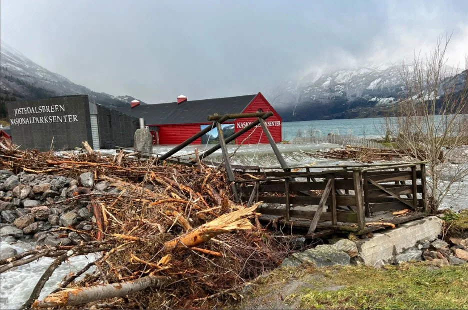
A blockage of trees and roots beneath the footbridge Photo: Fjordingen
Large amounts of water entered the
National Park Centre Photo: Fjordingen
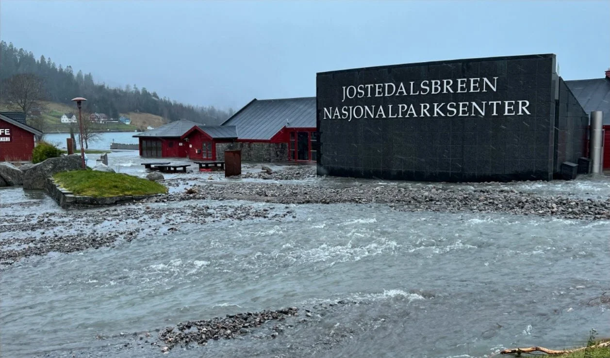
During Storm Jakob, which struck western Norway in late October and early November 2024, an event occurred that should never have happened. The Fosdøla River carried large quantities of rocks, gravel, trees, and debris downstream. A blockage formed beneath the footbridge at the National Park Centre, causing the river to change its course.
Large amounts of stones and sediment were deposited around the National Park Centre, and significant volumes of water entered the buildings.
An extensive clean-up operation followed. Large areas of forest have been cleared, and substantial amounts of sediment have been removed from the river channel. Nevertheless, similar events are likely to occur again in the future, as enormous quantities of loose material still remain in the upper parts of the valley.
View towards Fosdalskyrkja and Storskredfjellet Photo: Tarald Harstad
The photograph shows some of the glaciers that have produced enormous quantities of loose rock and sediment in the upper reaches of Fosdalen. Today, these glaciers are gradually melting away and retreating.
Fosdalsbreen, with Tafsehyrna on the left Photo: Rannveig Marit Mindresunde
Text: Asbjørn Berge, 2026