


The old mountain pasture road to Skjerdingsdalssetra
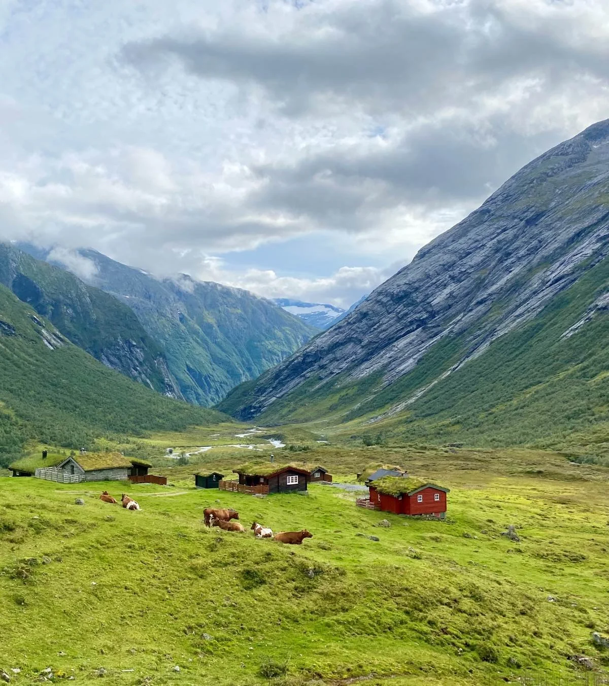
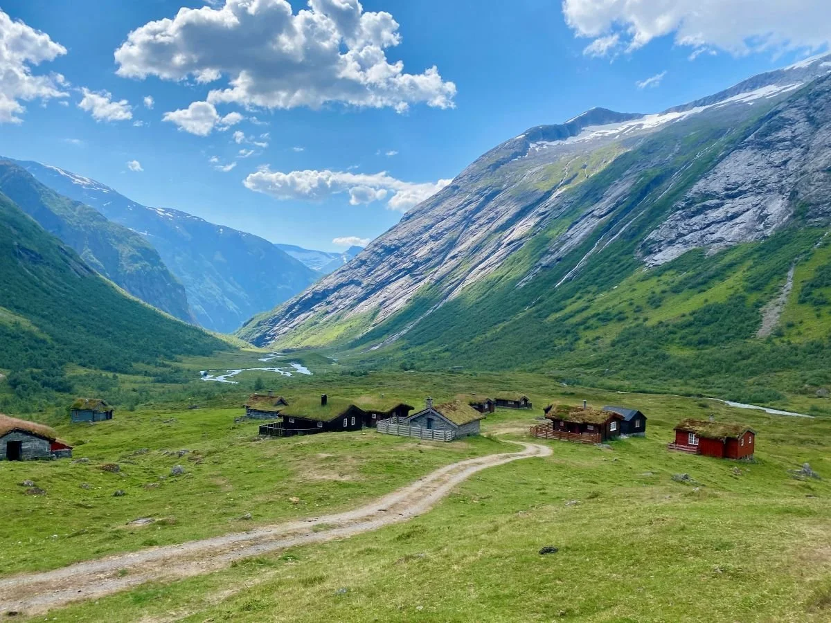
Skjerdingsdalssetra, with Glæra in the background
Skjerdingsdalssetra (summer farm) is idyllically located right by Highway 15 between the Ospeli Tunnel and the Grasdal Tunnel. Today, you can drive all the way to the summer farm, but before the new road over Strynefjellet was completed in 1978, the old mountain pasture road passed by the steep mountain section known as Glæra. The landscape here is dramatic, and quite a few animals have ended up in the gorge.
The old track branched off from the main road at the impressive Jøl Bridge, and from there it is about 4.5 kilometres to walk to the summer farm.
Unfortunately, the road is currently closed due to a rockfall at Glæra. Reopening it is a difficult and costly task, so it may take some time. Nevertheless, we include a description of this hike.
Difficulty: Moderate. Some narrow sections through Glæra. The path runs along a deep gorge.
Distance: 4.5 km one way.
Elevation gain: 360 metres.
Duration: Approx. 4.5 hours round trip.
Season: Spring to autumn.
Parking: You can park at Jøl Bridge.
Note: The path is currently closed at Glæra. It is not safe to pass the rockfall area!
It has been several years since the trail was last cleared.
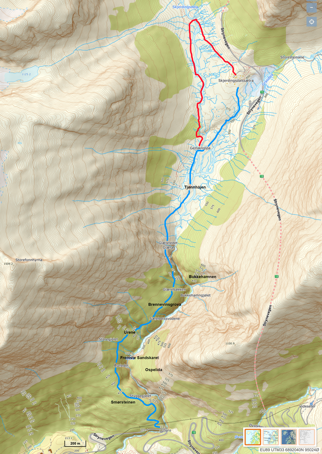
The map shows the old mountain pasture road to Skjerdingsdalssetra (blue line).
The red line indicates an alternative route via the new bridge a bit further into the valley.
Route description
The hike of just under 5 km between Jøl Bridge and Skjerdingsdalssetra can be walked in either direction. The starting point is either Jøl Bridge or Skjerdingsdalssetra, which lies at about 600 metres above sea level, slightly above where the rivers Skjerdingsdøla and Grasdøla meet. Highway 15, which opened in 1978, runs close by the summer farm.
In this description, the hike starts at the impressive Jøl Bridge, an arched stone bridge from 1883 that was a prerequisite for the construction of the old Strynefjellet road. Beneath the bridge flows the river Skjerdingsdøla on its way from Skjerdingsdalen to Hjelledalen. From the bridge, the path climbs steeply up the hillside (Åsen) on the western side of the river.

Jøl Bridge from 1883

The gorge seen from the bridge, almost 60 metres deep
On the right-hand side of the path up the first slope, there are remains of a guard hut from World War II. It was built by the Germans, who kept a round-the-clock watch here to ensure that no sabotage was carried out on Jøl Bridge, which was strategically important for the connection between Eastern and Western Norway.

Remains of the German guard hut
Further up lies Smørsteinen, which was a resting place for those who, in earlier times, transported dairy products home from the summer farm. The trail then passes Åseledet, where there used to be fences and a gate to prevent livestock from the outlying grazing lands in Skåre from wandering up to the seter on their own.
On the other side of the river lies Ospelida, where a fugitive is said to have lived in former times (probably around the 1400s). Clear traces of house sites can still be seen in the steep mountainside, which has difficult access and is only reachable by those familiar with the area.

The mountain pasture trail after it had recently been cleared
After a while, the trail makes a sharp 90-degree turn when crossing Styggejølet, before levelling out and then descending slightly through Urene. A large snowdrift often forms across the path here. The snow can remain well into the summer, but it is usually possible to pass.
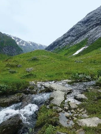
The trail then crosses a large stream and continues up a rocky scree slope before reaching Selebotsvodene, where the character of the path changes and it gradually enters a forest of mountain birch.
Below a large rock further up on the left-hand side lies “Brennevinsgrova”, which in earlier times provided access to cold spring water for travellers passing through. In recent years, however, the water has likely found new underground routes, as there is now little water to be found there.
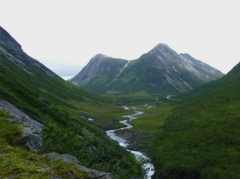
The trail continues through the mountain birch forest, and before ascending the steep Glærebakken, one can see the even steeper Bukkehamnen on the opposite side of the gorge. The name likely dates back to the time when goats were kept at the seter.
The trail passes through a dramatic and fascinating landscape, where the gorge below Glæra lies about 200 metres beneath the path. After passing Glæra, one reaches the remains of Glæreledet, which marks the boundary between the outlying land of Skåre and Skjerdingsdalssetra.

Glæra with polished rock slabs both above and below the trail

A rockslide is blocking the path through Glæra. It is not safe to pass here.
Skjerdingsdalssetra seen from Glæra

The waterfall where the Skjerdingsdøla river plunges down into the gorge
Tjønnhojen
On the way towards the summer farm, you pass Tjønnhojen, which is a terminal moraine formed by countless similar landslides that have repeatedly cleared loose material from the mountainside above and deposited it in the same location.

Geitekloppa
It is not far to walk from Tjønnhogjen to Geitekloppa. There, you can cross the Skjerdingsdøla river via a simple cable bridge. A basic wooden deck is dismantled before winter and put back in place in spring. From there, it is only a short walk of just under one kilometre to the summer farm.
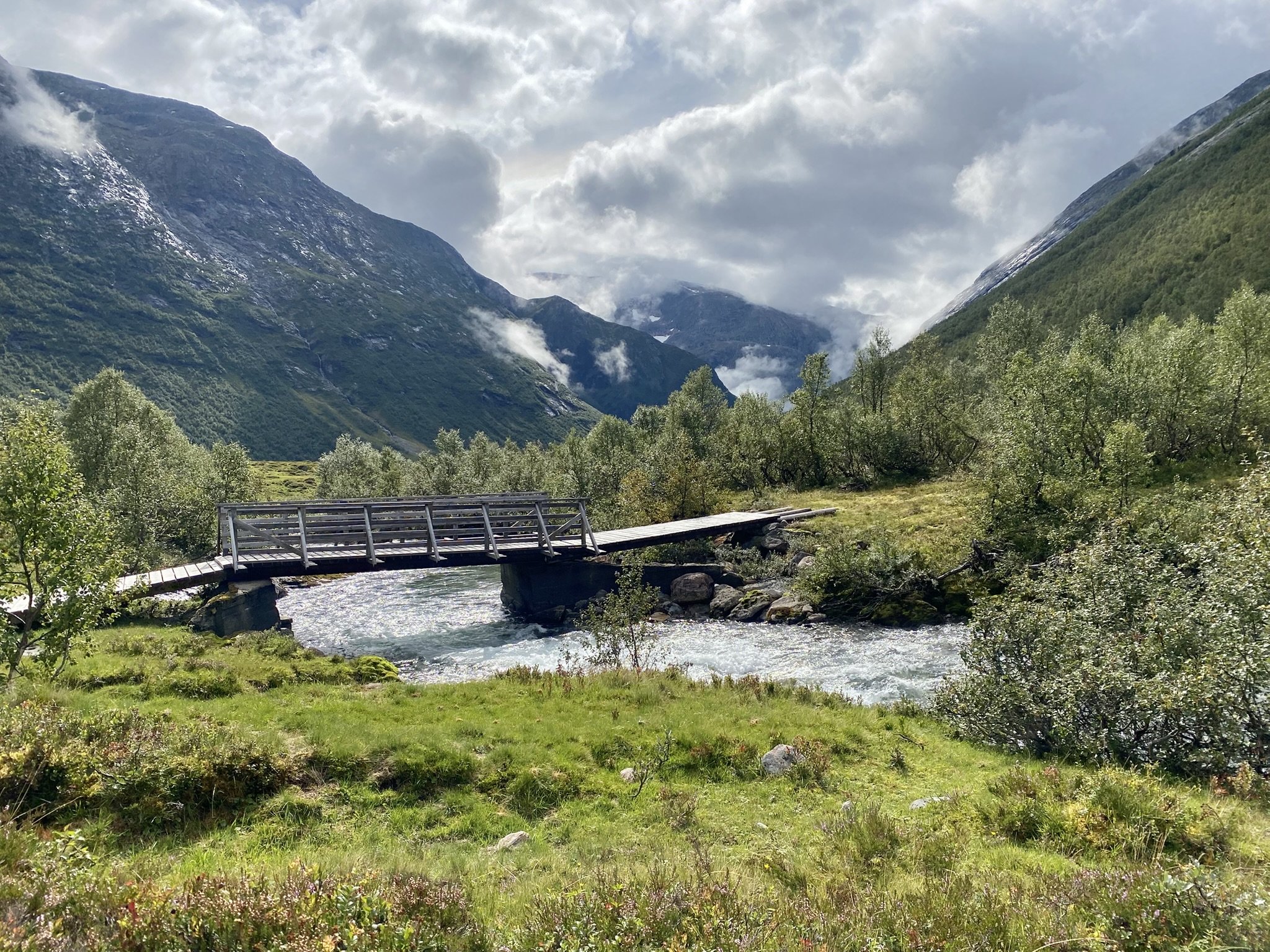
A new, solid bridge with steel beams a little further up the valley.
Instead of crossing Geitekloppa, you can follow the trail along the river until you reach a larger, newer permanent bridge with steel beams. The bridge is located in front of the summer farm, just upstream from the Tverrelva river, which flows down from Setreskarhynna. It is used by both cattle and sheep.
Skjerdingsdalssetra is idyllically located on a small rise. We look towards Glæra

The summer farm seen from Highway 15 (Rv15)
Text and photos: Berit Wetlesen and Jørgen Skåre, 2025