

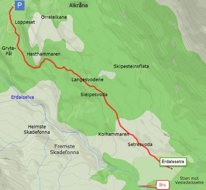
Hike to Erdalssetra


Erdalssetra is considered to be one of our most beautiful mountain farms. The road leading there has recently been upgraded, and it’s a trip most people can manage.
When you reach the farm, the valley levels out, and the many cows have large areas to graze. The huts are mostly in good condition, and several of them are of the old traditional type.
Difficulty: Easy. The trail has been recently upgraded. Some sections run along bare rock.
Length: 1.7 km one way
Elevation gain: 130 m
Duration: 2 hours round trip
Season: Spring – Autumn
Parking: You can park at the parking lot at Loppeset. Remember to pay the fee!
Note: If you park at Greidung, the hike will be more challenging.
There is no mobile coverage on the hike.
Hike description
Erdalssetra is one of our most beautiful summer farms. The landscape is open and free, but high, steep mountain walls are still not far away. Glaciers lie in the mountains and constantly send snow and rocks down the mountain sides, and the river runs in rapids down the valley. There is life in the landscape.
From the farm Greidung there is a toll road that bring you 2.2 km further in the direction of Erdalssetra and approx. 250 meters in hight. Here you can pay in cash or you can pay to
Setrevegen i Erdalen IBAN: NO0437951560368 SWIFT/BIC: SOFJ 22
From the car park to the summer farm, it is approx. 1.7 kilometers and almost 130 meters in height to go. You should allow two hours for the entire hike – from Greidung the double.
Sherpas from Nepal helped to restore the old path from the car park to the summer farm some years ago, and gravel has been laid on the path most of the stretch.
A short distance from the car park, the path splits. You can walk the old path past Loppeset, or you can follow a tractor road that has been built up in recent years. It won't be long before the two paths come together again.
Loppeset was a resting place for the girls and boys who went to the summer farm to milk the cows every afternoon and morning in the olden days, and they returned home every morning with the milk in a spesial milk pail on their back.
Further on, the path passes a stone that has stood there for many generations. With a little imagination, you can see a person, and the stone has been named Gryte-Pål. At all times, people have had a lot of fun with Gryte-Pål. You try to trick each other into bowing to him, but the tradition says that you should not salute Gryte-Pål!
Just before you get to Hesthammaren, you can see a small sign showing that here is the border with Jostedalsbreen National Park.
The name Hesthammaren comes from the fact that the horses used to graze in this area in the olden days.
When you have gone up the hill at Hesthammaren, the path flattens out. Here you can see straight towards Heimste Skadefonna on your right hand, a dangerous avalanche. In some years, this might be so large that it dams up the river and can cause damage further down in the valley.
Skadefonna often comes big in the middle of June. When it comes, it makes a very strong wind with a lot of snow and water in the air. Then it can be dangerous to stay in this area.
Fremste Skadefonna (see map) killed in ancient times cattles that sought their way home to this area early in the summer. The farmers then got together to build a wall to prevent this. This is called Muren (The Wall) to this day. They opened the wall after the avalanche had passed.
After a short stop, you continue up a steep hill, and then you are at Langesvodene. Here the path runs on rocky ground.
Midway on Langesvodene, you pass Tobakks-Jørn, a small rock on the right side. The tradition says that he should have some fresh "tobacco" as you pass.
Then you come to Sleipesvoda. "If you go out on Sleipesvoda, you'll fall, and you'll slide all the way down to the river." That's what the adults told the kids in olden times. Scaring the kids like this was not unusual a few generations ago.
Water usually flows down Sleipesvoda, and this makes it slippery. But there is no danger of slipping all the way to the river.
The path flattens out and you pass Kolhammaren. One can wonder if the name comes from the fact that coal has been burnt here in older days, but the most likely explanation is that the name comes from the dark colour.
When you arrive at Setresvoda, you can see the summer farm, and you are immediately there.
The Hike in Pictures

The toll road from Greidung towards Erdalssetra. Here you can pay in cash or you can pay to

Parking lot at the end of the road

View from Loppeset

The old path past Loppeset

Sherpas from Nepal have helped to upgrade the old path from the car park to the summer farm, and gravel has been laid on much of the stretch.

Gryte-Pål. In all ages, people have had a lot of fun with Gryte-Pål. One tries to trick each other into bowing to Gryte-Pål, but the tradition says that one should not salute Gryte-Pål!

Hesthammaren. The horses were put out to pasture in this area before the farms were divided and consolidated toward the end of the 19th century. At that time, the fields were mixed together like a patchwork quilt, making it impractical to use horses during the haymaking.
A rock shelter beneath Hesthammaren (slightly to the left of the photo) was used as a dwelling place in ancient times. Remains of charcoal indicate this.
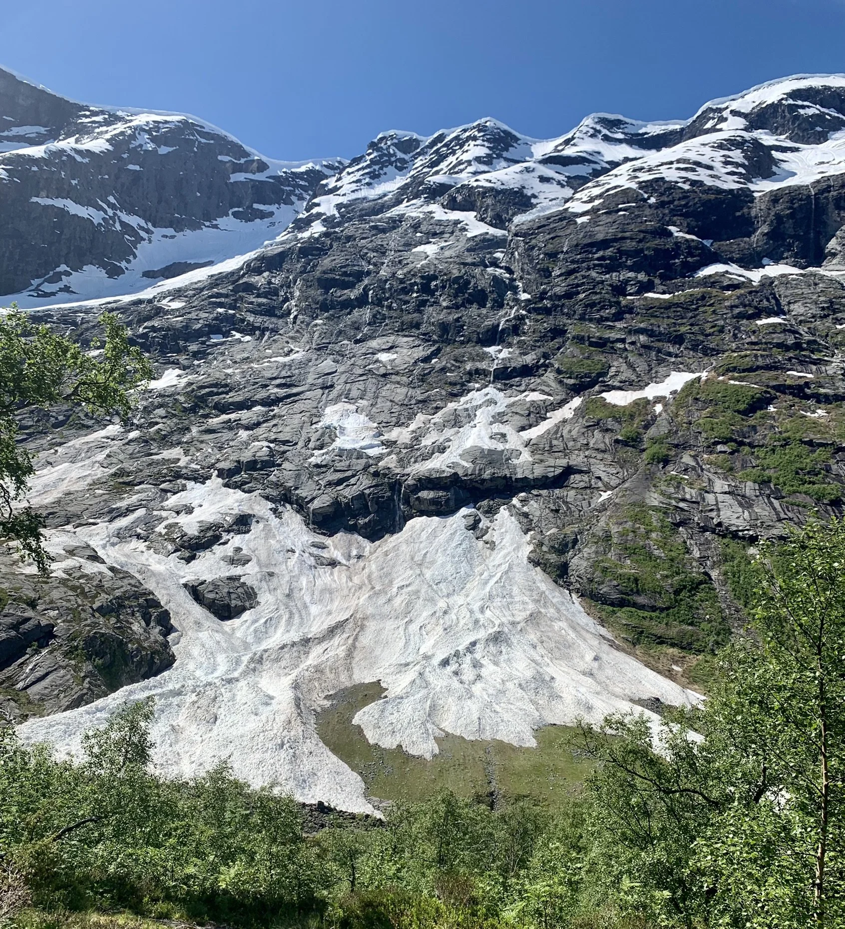
Here you have a view straight towards Heimste Skadefonna. This avalanche can some years go very big in the middle of june. Then it can be dangerous to stay in this area.

Langesvodene. Here the path runs along mountain bedrock a long distance.

The girls and boys were at the age of 14 or 15 when they took going to the summer farm to milk the cows. They had fun to make sure that Tobakks-Jørn had fresh “tobacco”. We can see at the picture that he's got some.

Langesvodene. Here the path runs along mountain bedrock a long distance.

Kolhammaren. The name probably comes from the fact that it is dark in color.

Setresvoda. When we get to Setresvoda, the valley opens up, and we can see the summer farm. Strynekåpa (a mountain) is surrounded by fog. To the right of this mountain the path leads towards Erdalsbreen (glacier). To the left is a path towards Vesledalsbreen (glacier).
Erdalssetra in mid-June – before the cows are brought up to the summer pasture.
Tur til Erdalssetra
Ein tur på setra i sommarkvelden,
når himlen logar som jonsokelden.
Når lauvet glitrar og fuglen syng,
og skogen angar av blom og lyng.
Rett opp i lida ved første stopp,
tett ved råsa, i høgste topp.
Ein bokfink syng sine klåre tonar,
han søkjer make og på kjærleik vonar.
Den bratte fjellsida svart og mektig,
med elv og fossar frå breen prektig.
Det blenkjer vakkert i stein og ur,
det skin mot alle som går på tur.
Litt snø som pyntar opp her og der,
og Skadefonna så brei og svær,
jau, den kan skremme med fonnvind stor,
og skrape bort både stein og jord.
Vi rundar Hesthammaren, går bakken opp,
vi ser mot Kåpa, den høgste topp.
Langesvodene og Sleipesvoda,
jau, namna held det som orda lovar.
Og Tobakks-Jørn står her rak og rett,
vegen vidare, så flat og lett.
Frå Setrekulen vi setra skimtar,
og fine brearmar mot oss glimtar.
Dei lune sela på rad og rekkjer,
dei smiler mot oss og tanken vekkjer,
på farne tider med lokk og song,
i gamle dagar – det var ein gong …
Jau, gå på setra i sommartida,
når naturen viser seg frå beste sida.
Det gjev oss glede og ro i sinnet,
ein betre balsam du knapt vil finne!
Marit Gjørven Berge
Sela på Erdalssetra

1 points to the stone walls of Martinsselet
2 points to the stone walls of Øvsteryggselet

The cabins at Erdalssetra in 1947 Photo: I Dårflot

The outdoor toilet at Erdalssetra
Just past the innermost cabin at Erdalssetra, on the right side of the path towards Vesledalssetra, you will find this toilet.
A few meters further along the path towards Vesledalssetra, on the left side, you can see a brook with clean, drinking water close to the path.
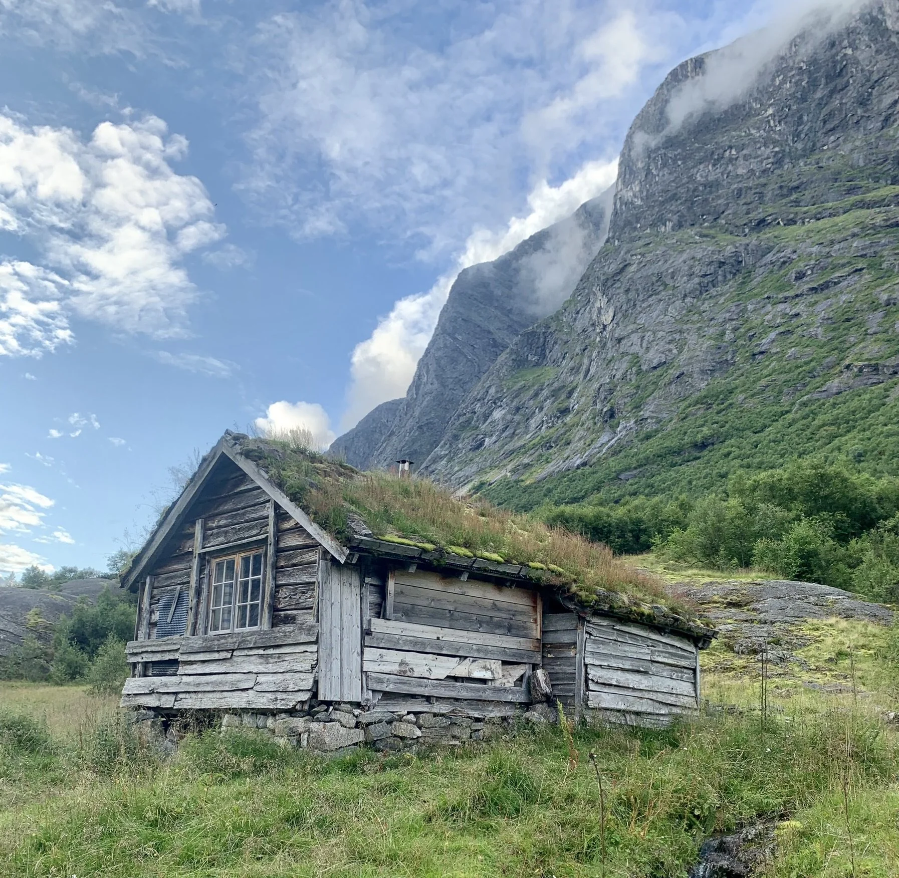
Ivaselet (cabin) is one of the oldest cabins at Erdalssetra.

Samelselet (cabin) is registered as a cultural heritage building. See the map below. The hut was built before 1900.

Small glaciers lie on the mountain sides and constantly send off snow, ice and stone. But the glaciers are shrinking year by year.

We see cows grazing on Grandane. To the left we see Seltuftefjellet with Trollurgjelet and to the right the Vesledalsbreen glacier.

We see the steep mountain wall on Tomefjellet (1835 masl.)
You can read more about the history of the mountain farm here.
Text: Asbjørn Berge, 2025
Photos: Marit og Asbjørn Berge